To date cellular telephone has become an important part of our lives. With the help of it we correspond, call each other and use mobile internet. But even now, when operators cellular communication They do everything to improve communication, there are failures, and sometimes the connection disappears or is completely absent. Not everyone knows how cellular communications work and what determines its quality. To cover the area and High Quality cellular communications, operator companies are increasingly building (installing) base stations. A base station map will help you stay connected. Each operator has a wide network of 3G (third generation) and 4G LTE (fourth generation) base stations. If you have not yet decided on the choice of operator or want to switch to another, you may be interested in the map of cellular base stations of the operator you need, which will show in detail the coverage area. The range of one station depends on the location and frequency range. 3G stations in megacities reach 500m, in open areas - up to 35km. 4G LTE stations - the radius can be different, optimally it is about 5 km, but if necessary it can be up to 30 km or even 100 km (if the antenna is raised sufficiently).
Operators mobile communications learned to combine low and high frequencies. For areas where a small number of subscribers live, but they occupy a large area, networks operating in low bands are ideal. And in large and densely populated cities, high-band networks are being built. Dual-band LTE networks are the future of mobile communications.
View the map and find out the coordinates of base stations mobile operators, and also understand the coverage areas of cellular operators depending on the region on various websites. Examples of such sites include the following resources:
- http://bsmaps.ru/maps.php - coverage areas of Megafon, MTS, Tele2 in the central federal district;
- http://tolyatti.beeline.ru/customers/beeline-on-map/ - Beeline coverage areas
- http://www.mts.ru/mobil_inet_and_tv/help/mts/coverage/ - MTS coverage area
The quality of cellular communications varies among operator companies. A people’s project, “Communication Quality,” has been launched on the State Services website (creating a map of the quality of cellular communications using mobile application"Connection quality"). https://www.gosuslugi.ru/555666/1/
On the Angry Citizen project, you can complain about poor communication quality.
If the coverage is unsatisfactory and there are areas that are not covered ("white spots"), then the connection is unstable and may fail. Our resource was created to solve these problems.
Here you can see the layout of base stations on the interactive
Detecting communication towers is not a criminal activity, but a fairly common task in remote regions and villages where the quality of coverage leaves much to be desired. How can you understand why this post gives better results than that wicket? The following tools and websites can help you navigate.
Of the English-language services, perhaps the best is opensignal.com, where you can select the operator and the required location. The map does not show towers, but does show coverage areas. Among the Russians, I can recommend netmonitor.ru - its database contains a lot of information about operator towers.
Some Android applications are also interesting. For example, OpenSignal displays a map of cell towers and Wi-Fi points(places with poor communication are also marked on the map), has a built-in compass and a speed checker.
Another interesting utility is Netmonitor. It can monitor GSM and CDMA networks, shows information about signal strength, contains a database of cell towers, supports devices with multiple SIM cards, and can also keep a log in CLF or KLM format.

Please note that Netmonitor has limitations when running on devices from some manufacturers. On Motorola, LG, Samsung, Acer and Huawei smartphones, the list of neighbors may be empty, and on Samsung devices, the signal strength may also not be displayed.
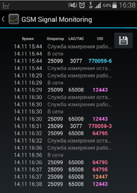
I also recommend the GSM Signal Monitoring application, which allows you to work with GSM, UMTS and LTE networks. It displays the change in signal level on a graph and shows neighboring cells (only in GSM networks). There is a data transfer rate monitor and the ability to track connection status, connection standard, cell and current zone identifiers (LAC/RNC/TAC) and received signal strength level (RSSI, as well as RSRP for LTE).
Knowing the data of the base station, you can access it through the website xinit.ru and obtain information about its location. In large cities, it doesn’t hurt to try to find folk maps with the location of the towers, but you should understand that the towers belong to to different operators. Plus, base stations are placed not only on poles, but also on the roofs of houses.
How to choose the right receiving kit for the Internet.
In order to choose the optimal kit for reliable Internet operation, you need to know the answers to several questions.
- Where and at what distance is the nearest base station with Internet access?
- Is there a direct line of sight to base station from the location where the antenna is supposed to be installed?
- How long is the RF reduction cable needed to connect the antenna?
There are two options to answer the first question.
First option:
The easiest way is to use coverage maps that cellular operators publish on their websites.
Below is a list of links to coverage maps of major cell phone carriers.
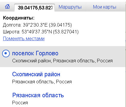
Let’s set ourselves the task of determining the possibility of receiving 3G Internet in the village of Nagishi, Ryazan region. Based on the coverage map of the MTS operator, we determine that the nearest base station is located in the village of Gorlovo, Ryazan region.
We find a more or less exact location of the base station. As a rule, the radiation pattern of the base station antennas is similar to a trefoil because the base uses three sector antennas with a radiation pattern of 120°, and the base will be located in the center of this figure.
Next, using the Yandex map, we find the distances between the client and the base station. This is necessary so as not to do extra work because if the distance is more than 30 km, then most likely it will not be possible to establish a 3G connection

Using the "Get Information" tool, we determine the coordinates of the 3G base station and the location of the proposed antenna installation.
We got the following coordinates:
Base 53°49′37.35″N 39°2′30.3″E
Client 53°50′20.41″N 38°55′7.82″E
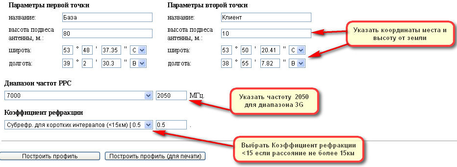
The first service is very simple and straightforward, you just need to enter the coordinates of the base and the client indicate the height from the surface of the earth for the base this is usually from 50 to 120m, for the client 10-15m.
There is one limitation this service will not be able to build a route if the coordinates of the place are more than 60° N or 60° S, which means that it will no longer be possible to calculate the route in the area of Arkhangelsk.
This is what happened in our case.

According to the route graph, it is clear that nothing prevents you from obtaining reliable reception at the antenna installation site, even if the base height is less (50m), direct visibility between the antennas will still be ensured.
When entering a resource, we immediately go to the tab Tower

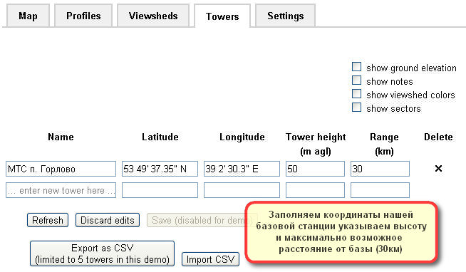
We delete the lists of base stations by clicking on the “cross” to the right of the table and fill in the data of our database to save, click Refresh
Go to the tab Map
We reduce the size of the map and move the “cross” to the location of the receiving antenna, guided by the names on the map and the coordinates at the bottom of the map.

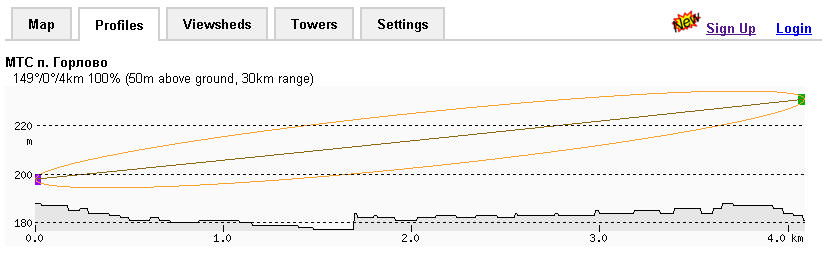
Clicking on the tab Profiles You can see the route profile. As you can see in the right figure, the route is open and can provide reliable 3G reception.
Scroll down the page to the heading "System Performance"
We will proceed from the fact that in order to obtain a signal level on the receiving side of at least -85 dBm, and a gain margin “for bad weather” of at least 10 dB.
![]()
We fill in the empty fields based on the fact that the receiving antenna has a gain of 14 dB, the transmitting one is 12 dB, the power of the base transmitter is 3 W, the loss in the base reduction cable is 2 dB, in the receiving antenna reduction cable is 5 dB. Click calculate and get the result above. Based on the calculated data, it turns out that the gain margin is 24 dB, that is, it will work in any weather. The signal level on the receiving side will be about -64 dB, which will allow you to have confident, stable Internet reception at the highest possible speed.
Second option:
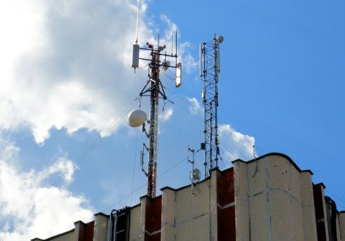
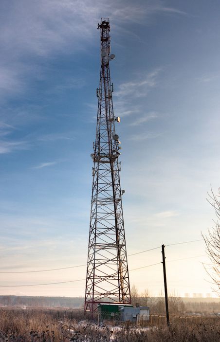
In order to find out the location of the base station, you need to take a phone with 3G support (nowadays this is no longer uncommon), and, guided by the signal strength indicator on the phone, move towards strengthening the signal until a structure similar to those shown below appears in your field of view:
Having marked the location of the station using maps http://maps.yandex.ru, we determine the distance to the installation site and coordinates.
The antenna should be installed in an open space, as high as possible from the ground surface and oriented towards the signal source. It is better to mount the antenna on a separate, grounded mast or wall of the house facing the base station. The antenna in the direction of the base station should not be blocked by vegetation and tall objects, even at a considerable distance and within a radius of about 8 meters from the axis of the path - this will greatly weaken the ability to receive 3G Internet. Remember that for the antenna to work, you need direct visibility to the base station! Also, you cannot install the antenna under the roof of the house, even from non-metallic parts (slate, rubber, roofing felt, etc.). Also, you should not install the antenna near the chimney; excessive uneven heating will damage the antenna.